Conversational geospatial intelligence
Every other AI assistant can describe a wildfire, a flood, a crop-stress pattern. ASKTERRA Geospatial Agent runs the analysis against live satellite imagery and streams back the actual map, chart, time-lapse, or report — computed, not generated.
Powered by Earth Engine, gemini-3.5-flash, MCP, and Google ADK.
What this is
ASKTERRA Geospatial Agent is a conversational agent that connects a multimodal LLM to live Earth observation data and returns the answer as a real artifact: an interactive map, a time-lapse, a publication-ready chart, or a multi-section report with embedded visualizations.
It is built on a multi-tenant framework you can re-skin, re-target, and extend without forking. What you're using now is one branded instance — RedCastle Resources's deployment — configured from a single YAML file.
Why not just use ChatGPT
How it works
"Map LCMS land cover over the Wasatch Front, 1985 vs 2024." No GIS knowledge, no API syntax.
Gemini chooses the dataset, the filter, the visualization, the legend — then writes the Python.
Code executes in a sandboxed REPL against Earth Engine. Per-user workload tags for attribution.
Interactive map, chart, time-lapse, or report — streamed inline. Stable URLs you can share.
What it produces
Hundreds of datasets — Sentinel-2, Landsat, MODIS, LCMS, NLCD, Dynamic World. Layer toggling, area charting, per-pixel inspection. Every map is a stable URL.
Sankey transition diagrams, before/after composites, time-lapse GIFs, zonal statistics. Decades of pixel-counted change — not approximations.
Legends, scale bars, inset locators, basemaps. GIFs and filmstrips for time-series. Resolution and styling fully parameterized.
Multi-section HTML reports with embedded maps, charts, summary tables, and AI-generated narratives that interpret the numbers. Email-ready in one prompt.
Wildfire severity, drought indices, snow persistence, weather forecasts, air quality, SAR flood extent. Catalog grows with Earth Engine's.
Save any working analysis as a parameterized script. Re-run on a new study area with one click — no LLM in the loop, no token cost.
Use cases
Real verticals. Real prompts. Real outputs — reproducible to the day, the AOI, and the underlying scene.
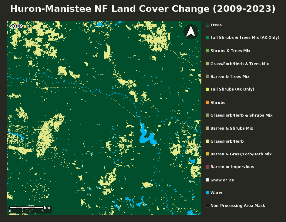
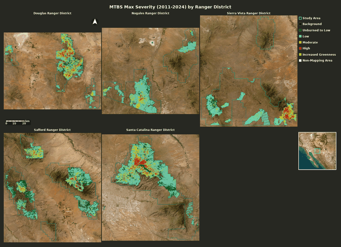
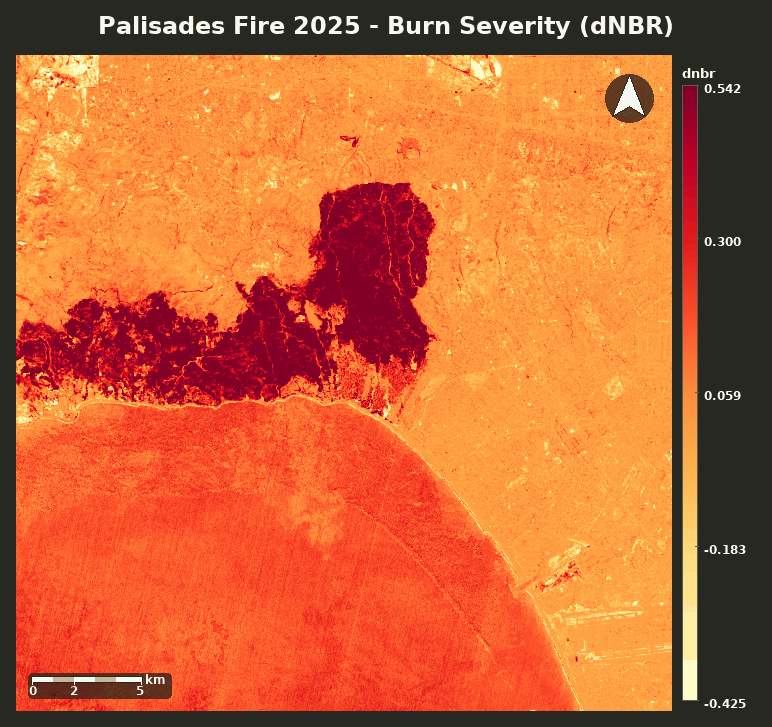
Burn severity, fuel-load classification, vegetation trend, forest-cover change. Reports analysts used to queue for weeks.
Try"Map MTBS burn severity for the Lolo NF, 2015–2024, and chart acres in each class."
Vegetation encroachment on transmission corridors, post-storm damage, site-selection feasibility, ROW monitoring.
Try"Where did NDVI drop >0.2 within 100m of this transmission line this summer?"
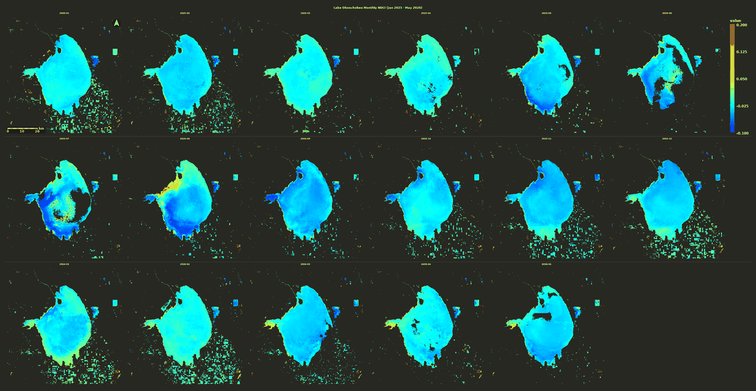
Snow persistence, watershed yield forecasting, flood extent from SAR, harmful algal-bloom monitoring, surface-water dynamics.
Try"Rank HUC-8 watersheds in the upper Colorado by April snow persistence, 2020–2024."
Crop-type classification, yield indicators, NDVI anomaly vs baseline, irrigation footprint, drought stress on growing-season vigor.
Try"Compare 2024 corn-belt NDVI to the 2015–2020 mean. Show counties with the biggest deficit."
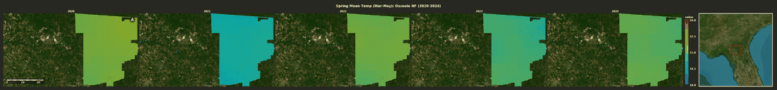
Temperature anomalies, drought indices, sea-surface temperature, air quality, biodiversity-area monitoring, protected-area pressure.
Try"Map PDSI over the Powder River basin, monthly 2020–2024, and chart basin-mean anomaly."
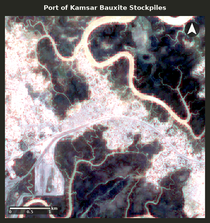
Stockpile activity, port throughput, mining-face progression, infrastructure expansion, land-use change affecting upstream operations.
Try"Bauxite stockpile area at the Port of Kamsar over the last 24 months."
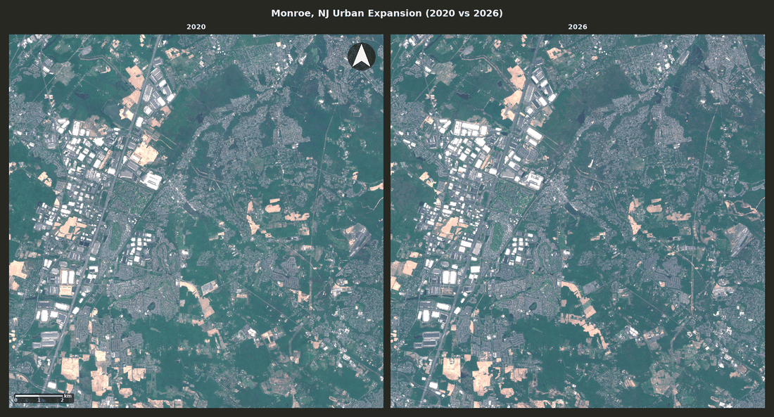
Built-up expansion, impervious-surface growth, vacant-lot detection, road-network change, urban heat-island mapping.
Try"New built area in Maricopa County, 2017 vs 2024, via Dynamic World."
Wildfire perimeter exposure, flood-zone overlap, hail-swath retro analysis, post-event portfolio damage estimation.
Try"Which ZIP codes in California sit inside MTBS perimeters from the last 5 years?"
Change detection on facilities of interest, SAR coverage of denied areas, infrastructure activity, post-event damage assessment.
Try"Most recent Sentinel-1 SAR over this AOI — flag any new construction since January."
Built to extend
Topology is configuration, not a code change. So is the tool surface. The same engine runs a single root agent or a hierarchy of specialists, each with its own model and its own tools.
Start with one strong root agent. Add in-process sub-agents for specialists — fact-checkers, citation-finders, domain experts in forestry or hydrology. Each layer has its own model, tools, instructions.
Delegate to remote agents over a standard protocol. Your customer's in-house GIS agent. A partner's analytical model. A vendor's domain agent. Each becomes a tool the root can call.
Plain Python functions you drop in. Local MCP servers (sandboxed subprocesses). Remote MCP servers over HTTP. Wire any in-house GIS service, third-party API, or specialty model the agent doesn't already know about.
Make it yours
What you're using right now is the AskTerra deployment, branded by RedCastle Resources. Another customer's deployment runs on the same engine with a different brand, a different agent topology, different MCP servers, and a different access policy — all from one YAML file.
Logos, fonts, dark + light palettes, hero copy, footer attribution.
Your URL, managed TLS, custom email.
Add MCP servers, Python tools, or A2A connectors and they appear in the agent's toolbelt.
Single agent. Multi-agent. Sub-agents. Hierarchies. All from config.
Allowlist emails, Workspace groups, or domains. Manage in Workspace, no redeploy.
Starter prompts that steer users toward the analyses your audience actually needs.
Cloud Run per tenant. Own GCP project. Own BigQuery, Cloud SQL, GCS, Secret Manager.
Model Armor screening. Per-user EE workload tags. Audit logs. Session signing.
Grounded by design
Every number, polygon, and pixel came from a documented Earth Engine compute. No hallucinated statistics. No fabricated maps.
Every session exports as runnable Python. Every saved script is parameterized. An analysis you did six months ago re-runs on today's imagery.
Every Earth Engine call carries a workload tag identifying user, session, and tenant. Per-user attribution. Per-user billing. Per-user audit.
Try AskTerra to see what conversational geospatial intelligence feels like on live data. Or talk to us about a branded instance for your team, your customers, or your vertical.